Home Multi-Country Search About Admin Login
Cenozoic
Cretaceous
Jurassic
Triassic
Permian
Carboniferous
Devonian
Early Paleozoic

Search by
Select Region(s) to search
Hold Ctrl (Windows/Linux) or Command (Mac) to select multiple
Kiu Lom Formation
Click to display on map of the Ancient World at:
Kiu Lom Fm base reconstruction

Kiu Lom Fm


Period: 
Permian

Age Interval: 
Lower Permian (11)


Province: 
Sukhothai Fold Belt

Type Locality and Naming

Kiu Lom Damsite, Lampang province. Parent unit: lower formation in Ngao Gr.

Synonym: หมวดหินกิว่ลม

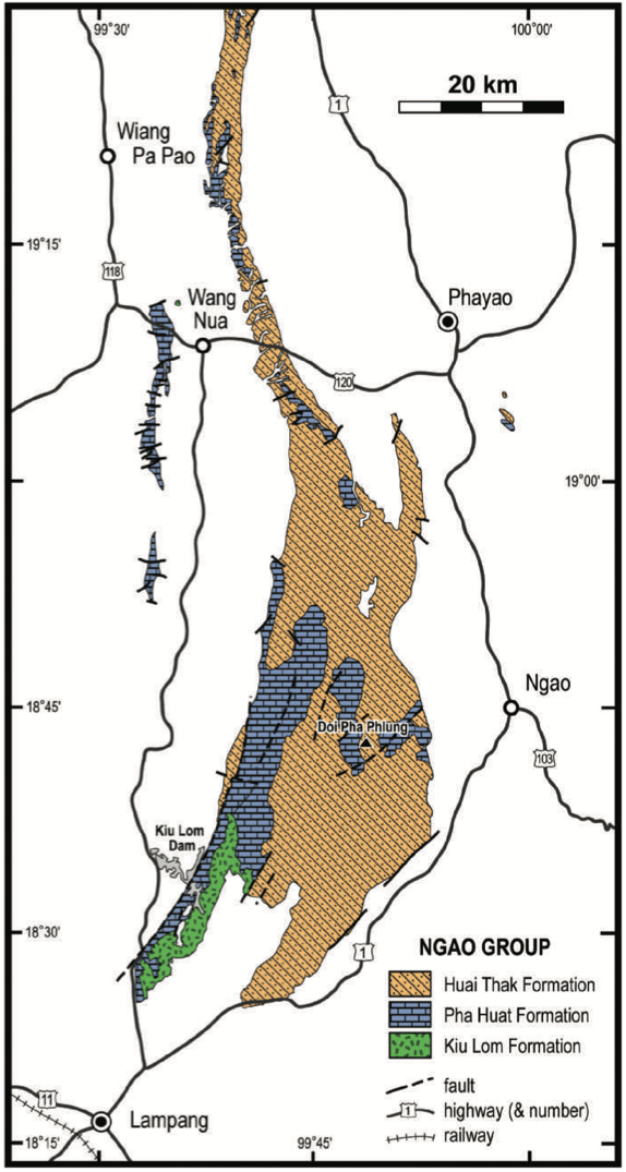
[Figure: Geological map of Ngao Group in Northern Thailand (data from Baum & Hahn 1977 and Charoenpravat et al. 1994). (from Ueno & Charoentitirat, 2011)]


Lithology and Thickness

Consists mainly of sandstone and shale with thin beds or lenses of limestone and rhyolitic and andesitic volcaniclastics. Andesite, rhyolite, tuff, agglomerate, tuffaceous sandstone and shale, sandstone; shale intercalated with calcareous shale and thin-bedded limestone. Basal volcanics overlie sandstone and shale of the Mae Tha Gr (Piyasin, 1972). Sandstone, shale calcareous shale, thin-bedded limestone with fusulinids (Bunopas, 1981). Thickness: 500-600 m (Piyasin, 1972; Bunopas, 1981)


Lithology Pattern: 
Clayey sandstone


Relationships and Distribution

Lower contact

"The basal contact is not known in the type area, but Piyasin (1972) reported that, east of Chiang Mai, a relatively thin succession (20–30 m thick) of his Kiu Lom Formation unconformably overlies the Mae Tha Gr. However, those rocks are in the Inthanon Zone and we (Ueno & Charoentitirat, 2011) exclude them from the Kiu Lom Fm." Therefore, the next older regional units are the Khanu Chert Fm, or the top of the Dan Lan Hoi Gr (Khao Khi Ma Fm).

Upper contact

Pha Huat Fm (conformable)

Regional extent

Northern Region: Chiang Mai, Lampang, Phrae provinces


GeoJSON

{"type":"Feature","geometry":{"type":"MultiPolygon","coordinates":[[[[99.59,20.42],[99.77,20.62],[100.02,20.62],[100.29,20.58],[100.56,20.32],[100.65,20.21],[100.86,20.03],[100.99,19.79],[101.06,19.55],[101.01,18.73],[100.44,17.98],[100.3,17.46],[100.3,17.2],[100.08,17.12],[99.93,16.92],[99.9,16.86],[99.64,16.65],[99.6,16.65],[99.3,16.91],[98.84,17.53],[98.8,17.99],[98.9,18.74],[99.29,19.31],[99.59,20.42]]]]}}

Fossils

"The fusuline Pseudoschwagerina sp. and brachiopods Linopro- ductus sp. and Juresania sp. are mentioned by Piyasin (1972). These fossils suggest an Early Permian age for the Kiu Lom Fm although they have not been substantiated by later workers. In a small section possibly referable to the Kiu Lom Fm NW of Wang Nua in northern Lampang Province, Ingavat & Jumnongthai (1988) reported a fusuline fauna containing a large and spherical Sphaeroschwagerina identified by them as S. glomerosa and ‘Monodiexodina’ sp. Although the latter form is now excluded from the relevant genus (Ueno 2006), this fauna rightly suggests a late Asselian – Sakmarian age and thus an Early Permian age for the Kiu Lom Formation." (Ueno & Charoentitirat, 2011).


Age 

late Asselian – Sakmarian. [Conformably overlain by Middle Permian Pha Huat Fm; therefore extended through Artinskian here for graphic purposes.]

Age Span: 

    Beginning stage: 
Asselian

    Fraction up in beginning stage: 
0.5

    Beginning date (Ma): 
297.19

    Ending stage: 
Kungurian

    Fraction up in the ending stage: 
0

    Ending date (Ma):  
282.00

Depositional setting

Open marine environment (Bunopas, 1981, 1983)


Depositional pattern:  


Additional Information

Correlation: Nam Mahoran Fm (Piyasin, 1972). Remarks: This formation was previously mapped as part of the Ratburi Gr (Piyasin, 1972)


Compiler:  

Wen Du -modified from Lexicon of Stratigraphic Names of Thailand (2013); and Katsumi Ueno & Thasinee Charoentitirat, 2011, Chapter5 Carboniferous and Permian in: Ridd, M.F., Barber, A.J., and Grow, M.J., editors, The Geology of Thailand, Geol. Soc. of London.